Dronecloud on track with Network Rail to secure CAA approval to deliver City Centre BVLOS drone operations for Critical National Infrastructure

Network Rail, Dronecloud and RUAS (the drone arm of Railscape) are working together on a project to create a Centrally Managed Drone Hub based at Network Rail’s Rail Operating Centre (ROC) in Birmingham. A key step to showcasing the journey to scalable drone operations for Critical National infrastructure. Dronecloud aims to develop this groundbreaking capability into a fully managed service for use across all Critical National Infrastructure (CNI).

Image: Drone carrying advanced surveillance equipment to help reduce train delays and improve safety
Image: Drone operations centre at Network Rail’s Rail Operating Centre (BROC), Birmingham

Drones save lives & money

“The Holy Grail is Beyond Visual Line of Sight or BVLOS”

Incident management costs UK infrastructure owners over £300m per year with railway crime costing Network Rail alone £1bn over the last decade.

Delays from trespass are becoming one of the most significant causes of disruption on the railway – with over 1.5 million minutes since April 2024. Routine asset maintenance tasks for Critical National Infrastructure are cumbersome and resource intensive, often putting lives at risk. Using drones will revolutionise the day-to-day running of infrastructure but current regulation means drone flights must stay within visual line of sight of the pilot.

The Holy Grail that unlocks scale is Beyond Visual Line of Sight drone flights or BVLOS for short.

Scaling drones for CNI

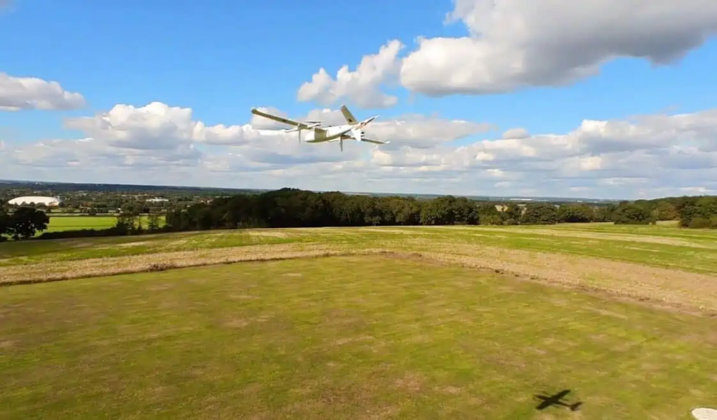
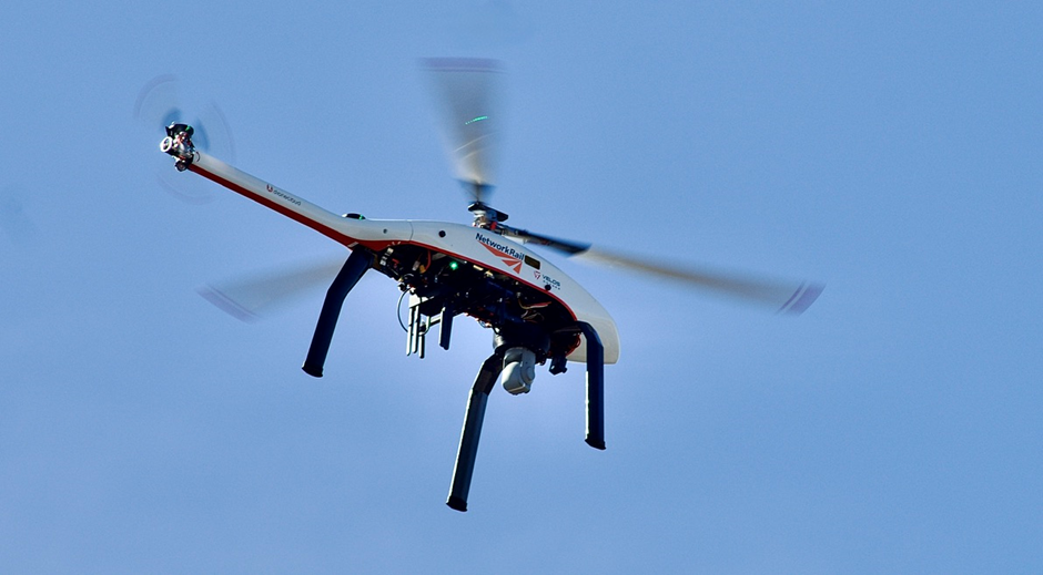
In a landmark development for the UK drone and rail industries, Dronecloud has collaborated with drone operator RUAS alongside drone manufacturers Velos Motors & Evolve dynamics to deliver one of the most advanced BVLOS deployments in the UK.

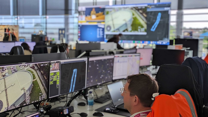
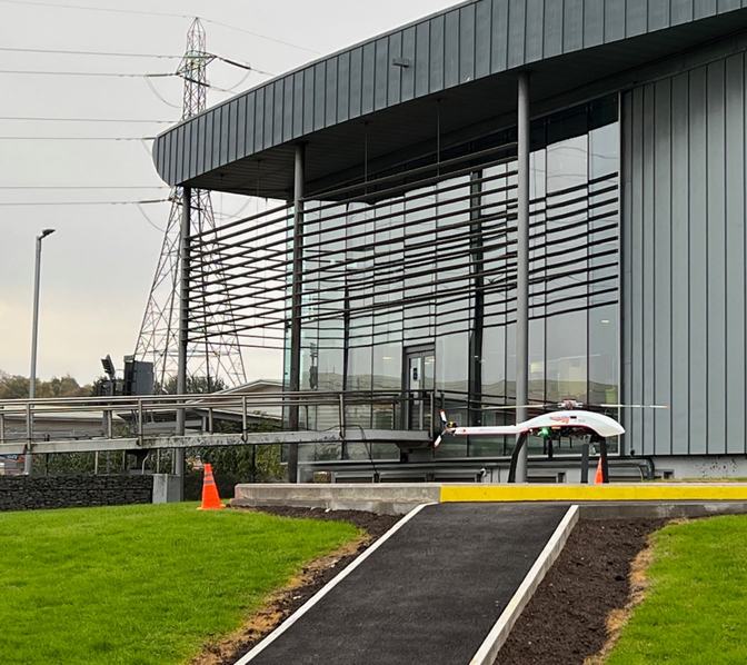
Working with Network Rail, the team is perusing a multi-step regulatory approval process and has created the UK’s first centrally managed Drone Operations Hub, designed to support 24/7 remote incident response and routine asset management anywhere within the Birmingham region.

Trials being carried out at the new Hub are already proving this potential by recently helping Network Rail and the British Transport Police avoid closing Birmingham New Street station, resulting in a cost saving of several hundred thousand pounds.

Image: Purpose built drone pad at Network Rail’s ROC in Birmingham

BVLOS – this is just the start

In line with the Civil Aviation Authority’s (CAA) BVLOS delivery model and roadmap (CAP-3038), the 1st step in the journey delivers approval to operate the centralised drone HUB with Visual Mitigation up to 8km of range. That approval proves the Hub concept is viable and showcases Dronecloud’s integrated Flight & Safety Management System (FMS/SMS) and Uncrewed Traffic Management (UTM) platform as the centrepiece driving drone solutions for Critical National Infrastructure (CNI).

The next phase scheduled for spring 2025, sees Dronecloud, Network Rail & RUAS working closely with the CAA’s new Atypical Air Environment (AAE) Test & Evaluation programme team to establish the Hub operation as one of the first in the UK to secure an AAE Operational Authorisation which will allow for the incremental increase in distance, initially up to 10km under pure BVLOS conditions, with subsequent phases planned to extend range up to 30km and beyond.

“Dronecloud’s vision is to deploy a managed service with multiple Hubs and satellite drones ports to deliver a common capability for all asset managers and drone operators needing to fly BVLOS across the UK. This will be a truly game-changing capability, opening the door for centralised mass-scale deployment of drones across all CNI (Critical National Infrastructure). As the industry matures, CNI use cases will help drive the design and development of UTM services. It’s critical for us to be at the forefront as we move into the implementation stage.”

Jan Domaradzki, CEO of Dronecloud

Blueprint for the Future: “Drone Zones” Set to Revolutionise UK Airspace by 2024

Dronecloud are one of the key partners in the UKRI Future Flight Challenge Project BLUEPRINT, delivering Operational Management and UAS Traffic Management services through the Dronecloud Platform.


In a major step towards realising the multi-billion-pound potential of drone technology in the UK, Project BLUEPRINT, a consortium of UK innovators, has unveiled its ambitious plans to integrate drones and crewed aircraft into the same airspace.


Drones have long faced challenges in terms of safety, privacy, and security concerns, resulting in regulators being risk averse in approving their widespread use. However, the UK’s aviation regulator, the Civil Aviation Authority (CAA), has been instrumental in bringing drone technology closer to becoming a reality with the introduction of temporary reserved areas (TRAs), or “Drone Zones.”

Traditionally, drones have been restricted to flying in closed-off or ‘segregated’ volumes of airspace to ensure the safety of other airspace users. However, the new policy concept introduced by the CAA and realised through Project BLUEPRINT aims to develop a roadmap for areas of airspace where drones and other aircraft can safely share the skies, paving the way for widespread commercial adoption and exploitation.

Project BLUEPRINT is aligned with the goals of the Future of Flight Industry Group and funded by UK Research & Innovation’s (UKRI’s) Future Flight Challenge, a £300 million program aimed at boosting innovations in the UK aviation sector. The consortium consists of over 10 partner companies, including two leading aerospace universities (Cranfield and Southampton), two UAS traffic management providers (Dronecloud and ANRA Technologies), Cranfield Airport, two avionics and platform manufacturers (Distributed Avionics and Sky-Drones), a drone operator (Future Aerial Innovations), and Ebeni, one of the UK’s leading aviation safety consultancies.

Project trials are set to demonstrate how drones and crewed aircraft can safely operate in the same airspace without requiring a drone pilot to spot aircraft. James Dunthorne, project lead and CEO of Neuron Innovations, a low-altitude aircraft tracking company, said, “We are excited to share our consortium plans and strategy with all industry so that these new policy concepts can help us all to prove drones and aircraft can co-exist in the same airspace without adding safety risks.”

The successful implementation of this project will not only enable the UK to roll out commercial drone use cases at scale but also serve as a model for other countries to follow, further solidifying the UK’s position as a leader in regulatory innovation and aviation.

With the launch of this new policy concept, the CAA is developing its understanding of shared airspace.  By working with industry to ensure a safe and scalable approach, it can put the UK in a leading position to be a world leader in drone technology. Projects such as BLUEPRINT offer a way to gather the evidence needed to do this

Representative from the CAA

Project BLUEPRINT is poised to transform the UK’s airspace and revolutionise the way drones are integrated into daily life. By 2024, the UK is expected to witness the widespread national rollout of drone zones, making it an integral part of various industries and applications. The project’s success will serve as a blueprint for other countries to follow and strengthen the UK’s position as a global leader in aviation and regulatory innovation.