UNCREWED TRAFFIC MANAGEMENT

Total airspace visibility.

Dronecloud's integrated UTM gives operators and CNI owners real-time situational awareness across every active flight in their network — from a single screen.
  • StrategicDeconfliction
  • ConformanceMonitoring
  • OperationalIntent
  • Real-timeTelemetry
  • AirspaceAwareness
  • ASTMStandards
Operational airspace map with UTM corridors, altitude volumes, aircraft tracks, and conflict alerting

The operational layer for low altitude airspace

Dronecloud UTM connects terrain, constraints, conformance, volumes, traffic, and intent into one aviation-grade operational picture — built for OCC workflows, not slide decks.

  • Unified airspace picture
  • Real-time operational coordination
  • Scalable digital infrastructure
  • Interoperable and standards based
UTM airspace layers: Operational Intent, Traffic & Aircraft, OIVs & Volumes, Conformance, Weather & Constraints, Terrain & Environment

Core UTM capabilities

Six core capabilities — each one is how OCC teams experience coordination under pressure.

Strategic Awareness

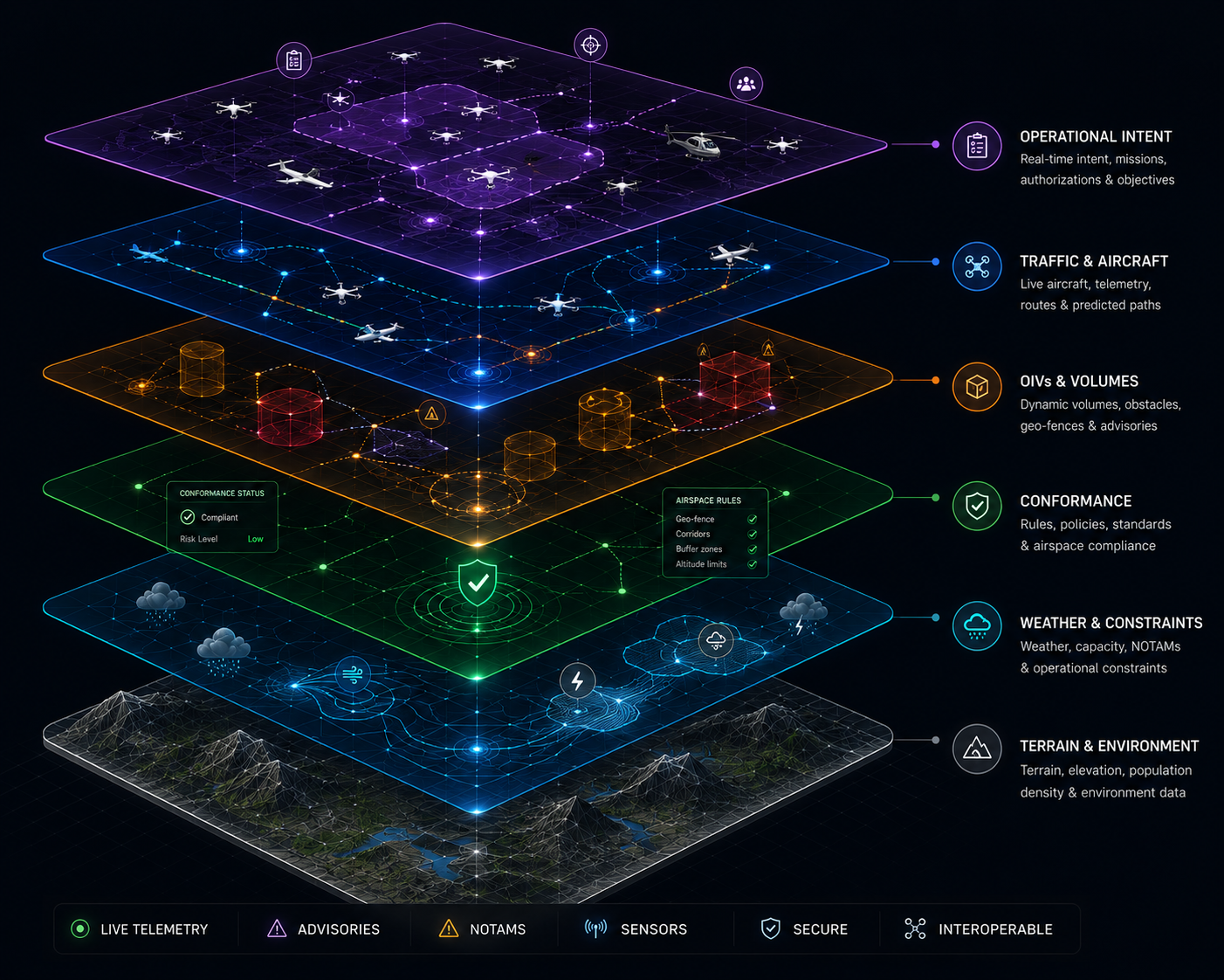
Comprehensive airspace awareness with real-time traffic, constraints and environmental data.

Operational Intent

Digital submission and management of operational intent and airspace authorisations.

Conformance Monitoring

Continuous verification of airspace, operator and vehicle conformance in real time.

Strategic Deconfliction

Automated conflict detection and deconfliction across manned and unmanned airspace users.

Real-time Telemetry

Live streaming telemetry and status monitoring for aircraft, systems and operations.

Advisory & Notification Services

Contextual advisories, notifications and alerts delivered to keep operations safe and informed.

Designed for complex operational ecosystems

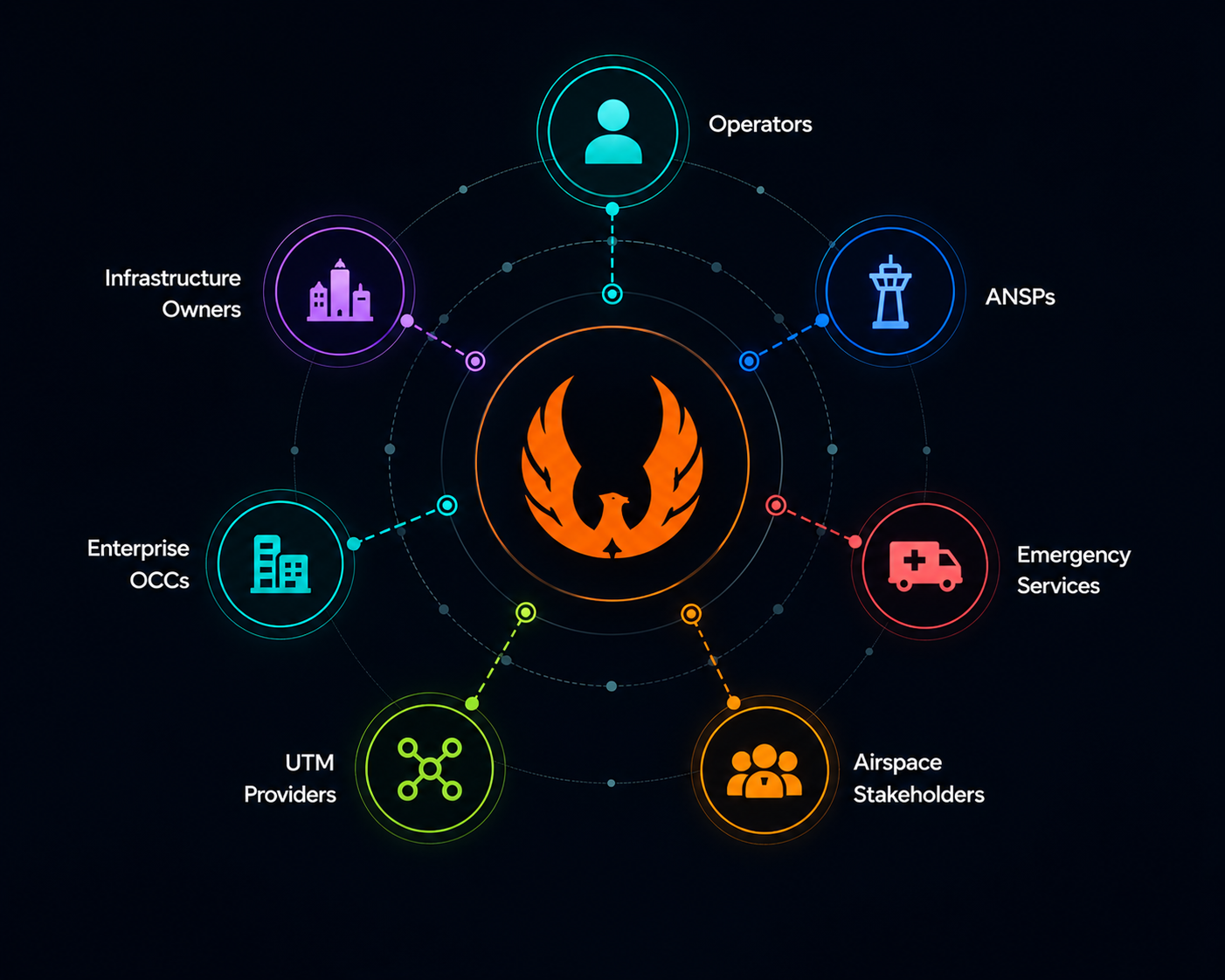
One coordination fabric linking operators, infrastructure, authorities, and service providers — with Dronecloud at the centre of live intent and telemetry.

Ecosystem diagram showing Dronecloud UTM connecting Operators, ANSPs, Emergency Services, Infrastructure Owners, Enterprise OCCs, UTM Providers, and Airspace Stakeholders

Real-time airspace coordination

Command-centre density: active operations, aircraft state, utilisation, and alert taxonomy — aligned to how OCC teams actually work airspace.

Live UTM airspace coordination map showing geo-fences, corridors and aircraft

P-352

1200FT

CONFLICT

HIGH PRIORITY

Aircraft StatusView all
  • A-021

    3400FT · 245KT · 92%

    On Track
  • P-045

    1200FT · 120KT · 89%

    On Track
  • D-142

    600FT · 45KT · 90%

    On Track
Airspace Utilisation
68%Normal
  • Available32%
  • In Use52%
  • Restricted16%
System Status
  • Data Links
    97%
  • Surveillance
    95%
  • Telemetry
    98%
  • Notifications
    3 New
AlertsView all
  • Conflict Detected
    High
  • Airspace Advisory
    Medium
  • Weather Advisory
    Low

Built on open standards

Traditional closed systems

  • Proprietary and siloed
  • Difficult integration
  • Limited scalability
  • Vendor lock-in
  • Opaque operations
  • Harder to future proof
Dronecloud

Open interoperable UTM

  • Open standards (ASTM F3548)
  • Seamless interoperability
  • Scalable and flexible
  • Multi-vendor ecosystem
  • Operational transparency
  • Future ready by design

Dronecloud UTM is built on open standards and open APIs enabling federated UTM ecosystems, shared situational awareness and true interoperability.

ASTM F3548
Open APIs

Build scalable drone operations with enterprise UTM

Speak with Dronecloud about deploying operationally proven UTM infrastructure for BVLOS and infrastructure-scale drone operations.